Where were the Caribbean mangroves during the Last Glacial Maximum?
Where were the Caribbean mangroves during the Last Glacial Maximum?
Rull, V.
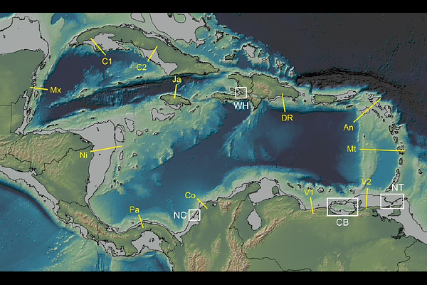
AbstractDuring the Last Glacial Maximum (LGM), when global sea levels dropped by ~132 m, the Caribbean continental shelf was fully exposed, which drastically reduced the flat topographical habitat necessary for mangrove growth. It has been proposed that mangroves survived in flat microsites beyond the shelf break and later expanded from these microrefugia to their current distribution after the LGM. However, this hypothesis remains untested. This study aims to identify potential refugia by locating flat areas around the -132 m isobath using Global Multiresolution Topography (GMRT) images. A significant ~200-km-long potential refugium was identified on the northern Trinidad (NT) shelf, along with several scattered kilometer-scale microrefugia near the Cariaco Basin (CB) in northeastern Venezuela. Additionally, two isolated prospective microrefugia were detected in northern Colombia (NC) and western Hispaniola (WH). The remaining LGM Caribbean coasts were considered unsuitable for mangrove growth. The NT refugium, along with the CB microrefugia, may have served as the primary sources for subsequent mangrove expansion. This expansion was likely facilitated by postglacial sea-level rise and the SE-NE Caribbean Current (CC), which would have acted as a major agent for propagule dispersal. The next step is to core the prospective refugial areas with the aid of seismic exploratory surveys, particularly the NT region, to determine whether mangroves actually grew there during the LGM. This exploratory microtopographical survey not only supports the microrefugial hypothesis but also narrows the focus to the most promising areas, significantly reducing the time, effort, and resources required for future seismic and coring campaigns.