A comparison shopper's guide to forest datasets
A comparison shopper's guide to forest datasets
Lee, L. G.; Pasquarella, V. J.; Glass, B.; Morreale, L. L.; Chung, N.; Gao, X.; Thompson, J.
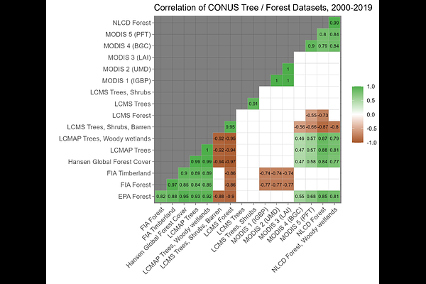
AbstractRecent advances in remote sensing, data availability, and cloud-based computing have led to a rapid expansion of publicly accessible datasets characterizing forest cover and land use. These datasets are widely used in ecological research, natural resource management, and policymaking. However, the sheer number of available products, and the often-subtle differences among them, pose significant challenges for users seeking the most appropriate dataset for their specific objectives. Here, we evaluate 27 derived products from 12 publicly available sources that quantify tree or forest cover and use across the conterminous United States (CONUS), with temporal coverage ranging from 5 to 30 years. The products include both satellite-based remote sensing data and ground-based national forest inventory data. We ask: How, why, and where do these datasets differ in their estimates of forest extent and change over time? Our analysis reveals that estimates of total forest area at the CONUS scale differ by over 2,000,000 km^2, and correlations among forest change estimates vary widely in both direction and statistical significance. To support dataset selection and interpretation, we developed an open-access map comparison tool using Google Earth Engine. Our findings highlight the substantial implications of dataset choice for understanding forest dynamics and underscore the need for careful selection and transparent reporting in forest-related analyses.